Road realignments denied on £1.3bn A66 Northern Trans Pennine upgrade for fear of increased flood risk
This post was originally published on this site
The Planning Inspectorate has rejected National Highways’ application to realign two roads as part of its £1.3bn A66 Northern Trans Pennine upgrade as they might increase flood risk in the area.
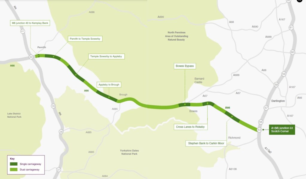
The dualling of the A66 between M6 junction 40 (Penrith) and the A1 at Scotch Corner will see the single-lane sections of the road through the Pennines made into dual carriageway, while key junctions will be improved. The 80km stretch between the M6 and the A1 is a vital artery in east-west routing in the North, with a quarter of the traffic being freight – more than double the national average. It is also the most dangerous road in the country, with 50% more fatalities than any other route.
The project will be split up into four parts and delivered by four major contractors working in collaboration: Keltbray, Costain, Kier and Balfour Beatty. It is a pathfinding project for the government’s Project Speed initiative, and should see the road upgrades delivered in five years rather than the initially forecast 10 years.
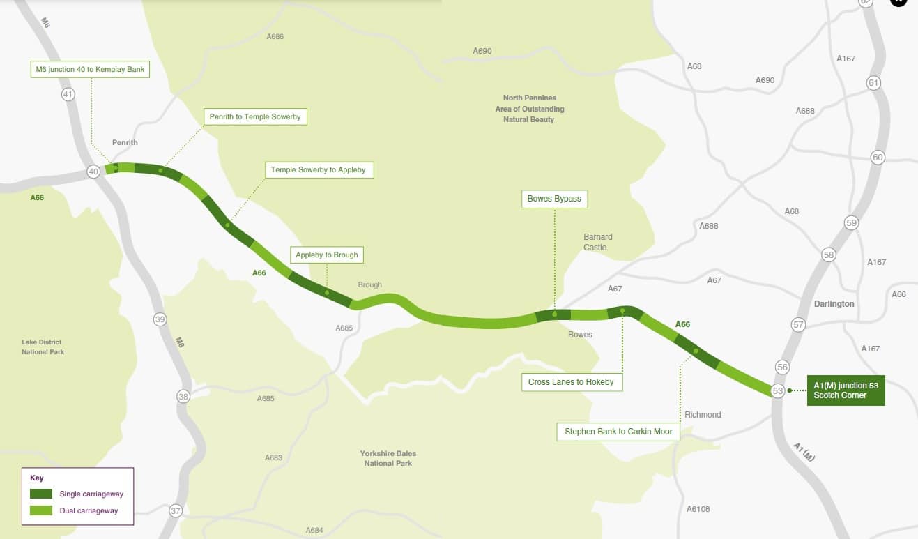
A66 Trans Pennine upgrade project map
However, National Highways has not yet had its development consent order (DCO) application for the project granted by the Planning Inspectorate. The roads operator submitted 24 updates to its DCO application in March and has this week learned that the Planning Inspectorate has accepted all but two.
The two rejections are for the realignment of Warcop westbound junction and the realignment of the de-trunked A66 closer to the new dual carriageway at Warcop. The Planning Inspectorate has said that the requests do not feature sufficient information in relation to the flood risk impacts to features of the River Eden Special Area of Conservation (SAC). The Environment Agency has also commented that both changes “potentially give rise to a risk of a new significant adverse effect because of changes to flood risk.”
The suggested change to the alignment of the de-trunked A66 also removes a planned crossing for otters, and the Planning Inspectorate is concerned that this may introduce a new significant effect on the River Eden SAC and its features.
The suggested realignment of the Warcop westbound junction would remove an attenuation pond, and does not suggest an alternative location elsewhere. This is crucial as this is an area of known flooding and sensitive environment.
Because both changes reduce the number of watercourse crossings and mitigation in the area, which could undermine the assessment and conclusions of the environmental statement and habitat regulations assessment, they have been rejected.
The other 22 updates have been accepted into the DCO application as they are not considered to materially change the scope of the project, but there are a couple of notable changes.
The Planning Inspectorate has noted that the request to remove the Langrigg westbound junction, revise the Langrigg Lane link and shorten Flitholme Road would see the road layout “considerably altered from that in the application”. Nonetheless it is satisfied that the changes are not so substantial as to constitute a materially different project and do not change the conclusions of the environmental statement, so it has been accepted.
There is also a request to reorient Kemplay Bank junction, which has been accepted with the notification that additional land will be required. Parties with an interest in the affected land have already consented, so it is not considered a significant change to the plan and has been accepted.
Interested parties can make comments on the changes until 9 May. The project’s DCO examination will conclude on 29 May.
The Planning Inspectorate will then make its recommendation to the secretary of state by 29 August. The secretary of state will announce the decision in November. If it is granted, work on the project will commence in the new year.
Outcomes of A66 Trans-Pennine upgrade
- Widen each of the roads approaching M6 junction 40 (M6 North, M6 South, A66 East, A66 West and A592) to provide additional lanes and a dedicated left turn; each arm would be controlled using traffic signals
- Widen the existing dual carriageway between M6 junction 40 and Kemplay Bank to three lanes in each direction
- Construct a new dual-carriageway underpass below the existing Kemplay Bank roundabout – enabling free-flowing traffic along the A66 and improving access to Penrith and the A6
- Create new slip roads to the A6 and A686 at Kemplay Bank roundabout, allowing drivers to safely join and leave the A66 in both directions. This will also serve the local road network with links to Penrith, Eamont Bridge and other local areas
- Re-route cycleways and footways around the Kemplay Bank roundabout
- Reduce the speed limit to 50mph (80km/h) (both directions) between Kemplay Bank and M6 junction 40 to create a safer driving experience for all road users
- The installation and upgrading of the traffic signals at M6 junction 40 and Kemplay Bank to control traffic movements and to create safer crossing points for pedestrians and cyclists.
Like what you’ve read? To receive New Civil Engineer’s daily and weekly newsletters click here.


Responses